
陳睿淵 Chen Rui-yuan
作品圖片 〈1° 15'57.3"N 103° 30'43.3"E〉 (點擊將開啟燈箱)
作品圖片 〈1° 34'24.6"N 103° 34'33.7"E〉 (點擊將開啟燈箱)
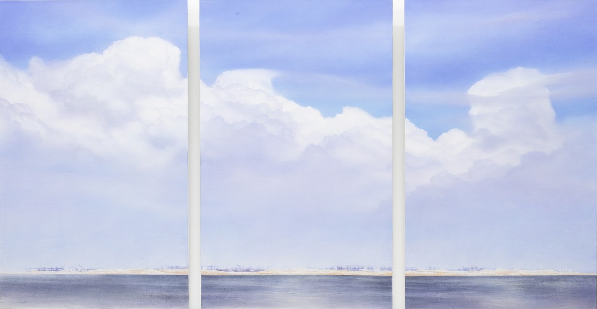
〈1° 15'57.3"N 103° 30'43.3"E〉 〈1° 15'57.3"N 103° 30'43.3"E〉
作者 陳睿淵 Author Chen Rui-yuan
媒材 墨、壓克力、礦物顏料、畫布 Medium Ink, acrylic, mineral pigments, canvas
國家 馬來西亞 Country Malaysia
尺寸 130 × 250 cm Size 130 × 250 cm
作品賞析 Artwork Appreciation
自大學來台求學,在此地生活已經十年,期間作品皆以台灣人造景物為題材。此作嘗試回望家鄉馬來西亞,紀錄行旅西馬半島南端時所走訪的丹絨比艾地質國家公園,該公園以位處歐亞大陸最南端的極點而聞名。我站在陸地最南端的紀念碑下,眺望南海,赫然看見天海之間夾雜一片填海工程,遼闊的沙洲上矗立著許多鋼骨結構和忙碌運作的機具。這幅光景讓我思忖,悠長的板塊移動所形塑的地理樣貌,在人類活動的介入下,瞬間就可能被改變。我以當時駐足遠眺的位置座標命名,紀錄這個我曾經立足,或許不久將來就不再是歐亞大陸最南端的位置。並且,觀者觀看畫中景物之餘,祗要在地圖上輸入座標,就能從衛星圖上一探究竟,對照人造與自然的糾纏關係。
Since arriving for university, it has been ten years that I’ve resided in Taiwan. During this time, my works have thematically revolved around Taiwan’s man-made scenery. This particular piece, however, marks a return to my home of Malaysia. It records a visit made to Malaysia’s Tanjung Piai National Park which lays at the southernmost tip of Peninsular Malaysia and is famous for being the southernmost point of the Eurasian continent. On that particular day, I stood under the monument proclaiming Eurasia’s southernmost point, and looked out over the horizon towards the South China Sea. To my surprise, straddled between the sky and sea, I saw an ongoing land reclamation project, replete with steel structures and busy machinery crawling over a vast sandbar. This scene made me consider how geographical features produced by millions of years of tectonics can be changed in a relative instant by human activity. This particular piece is named after the GPS coordinates of where I stood that day—a location that may not be the southernmost tip of Eurasia much longer. In addition to appreciating the scene in this painting, viewers are encouraged to input the coordinates to get a real-world, satellite view of the exact location and the entanglements between man-made structures and nature present there.
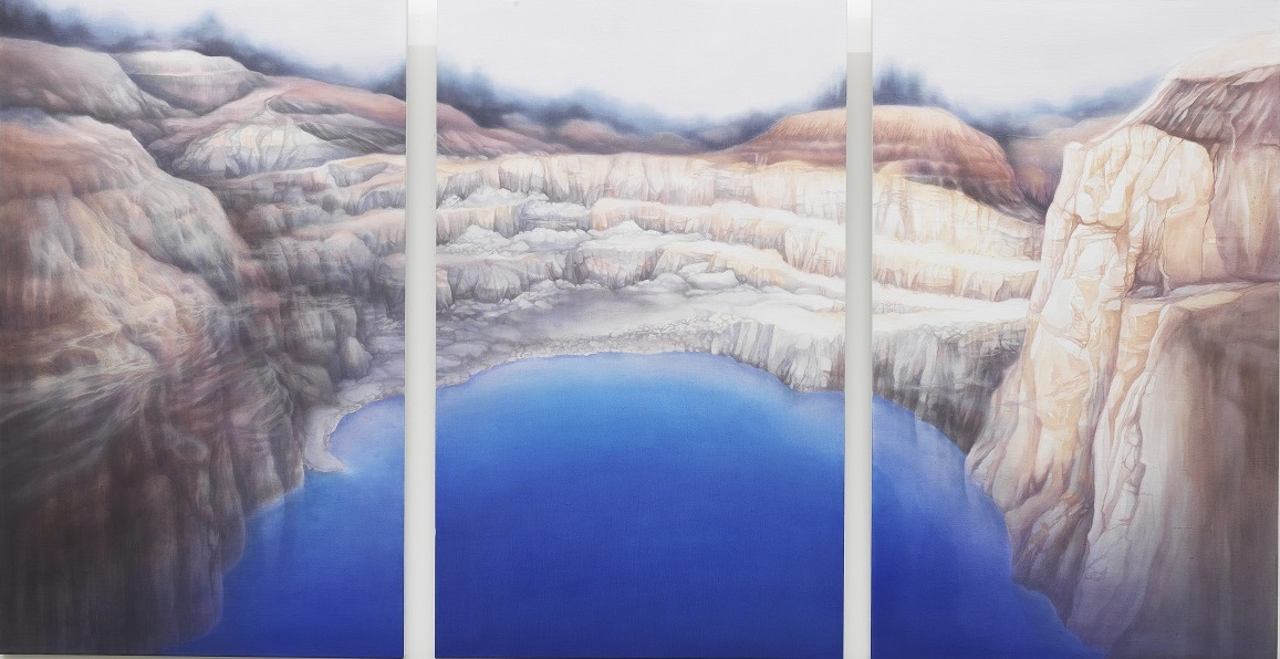
〈1° 34'24.6"N 103° 34'33.7"E〉 〈1° 34'24.6"N 103° 34'33.7"E〉
作者 陳睿淵 Author Chen Rui-yuan
媒材 壓克力、礦物顏料、畫布 Medium Acrylic, mineral pigments, canvas
國家 馬來西亞 Country Malaysia
尺寸 130 × 250 cm Size 130 × 250 cm
作品賞析 Artwork Appreciation
此作嘗試回望家鄉馬來西亞,紀錄行旅西馬半島南端時,所走訪的一處旅客間口耳相傳的奇幻湖景。湛藍的湖泊乍看之下是一處自然風光,但實為一座廢礦湖,湖水也因為採礦活動,蘊含礦物質使其呈現鮮豔的藍色。我以當時觀覽湖景的站立處座標為作品命名,期望觀者好奇之下查詢座標,便會在衛星圖上看到湖岸的小路,通往不遠處的砂石場。
This piece harkens back to a trip I took to my home country of Malaysia. During my travels in the southern tip of Peninsular Malaysia, travelers spoke of a fantastical lake found off the beaten path. At first glance the lake looks natural, but is in fact the remains of an abandoned mine. Due to the unearthed mineral deposits in the area, the lake's waters appear astoundingly blue. This piece is named after the GPS coordinates of where I stood that day as I gazed upon the lake. I hope that the public will, out of curiosity, check the coordinates themselves. On the corresponding satellite image, they will see a small lakeshore path leading to a nearby quarry.